On the Cubango River

Heading east from Ongula, on a surprisingly good road, we stopped for the night at a lodge on the river that forms part of the Namibian/Angolan border. The Rio Cubango rises in Angola’s highlands and heads south-east to form that border for a while, before being joined by the Cuito, another Angolan river, and later becoming the mighty Okavango. It was quite surreal looking across the river into Angola, something that would have been totally out of the question when I was younger and the area was still ravaged by war.

Taranga Safari Lodge is perched right on the edge of the Cubango, with permanently erected tents on platforms high enough to avoid having to worry about hippos or crocs. A floating bar on the river was a good spot for sunset photos with local people moving around on their traditional mokoros and lots of birds to be seen.

The birding was great, in fact. Between the river’s edge and the 11 hectares of bushveld with a self-guided walk and watering hole, there was a lot to find. I added at least nine new species and rediscovered a few that I hadn’t seen for a long time. Of course, I only managed decent images of some but I’m really happy that one of those I did capture was the stunning Violet-backed Starlings (still prefer their old name of Plum-coloured Starling).

Advertisement

Far North Queensland

This time last year I was lucky enough to spend a week in Far North Queensland, exploring the Cairns area with my daughter. I’ve always wanted to visit this area, largely because of the interesting birds that can be found there. The first day started well, with a new species (White-breasted Woodswallows) before I’d even left the airport . Once I had collected the camper van and Sarah had arrived from Sydney, we paid a quick visit to the Cairns Esplanade. Not the best time of day to bird by that stage, but the sun was shining and I managed a few decent images of another new species, a Peaceful Dove.

Then we set off to find our campsite for the first couple of nights. We stayed at the Speewah Conservation Park, a lovely spot near Kuranda. Definitely not recommended for caravans though – the road in is pretty steep in places. The first morning there were lots of birds calling in the rainforest, which got a bit frustrating as they were often really hard to spot. The Brown Cuckoo-doves were friendly and I got to know their call quite quickly. I do find birding in completely new places can be challenging if the vegetation is dense, as I don’t have any idea what all the calls belong to (Shazam for bird calls would be great).

We decided to stay up on the escarpment for the day and explore some of the waterfalls a bit further south. As you can see below, it was a very overcast (and sometimes wet) day so not the greatest for photographing birds. We had a fun time though, swimming at the Elinjaa Falls and seeing a good range of new birds, including the strange Pheasant Coucal. I have added the rather poor photo of  a Grey-Headed Robin to show the challenges of birding in the rainforest – no light and so many leaves for the birds to hide behind!

The following day we explored Kuranda and the Barron Gorge area, and then headed for Port Douglas on the coast. Sarah was not impressed with the beaches we stopped at – we are very spoilt in Western Australia – but we did find Port Douglas very attractive. After waking up to more interesting bird calls (I did spot one of the culprits – the Yellow Oriole), a visit to Mossman Gorge was in order. On the shuttle bus into the gorge, some tour guides were talking about an unusual sighting – and although we had gone for the self-guided option, we were lucky to be in the right place when they were pointing out the very cryptic Northern Leaf-tailed Gecko to their clients. We waited for everyone to move on and had a good look – I don’t how someone spotted it on the lichen covered tree trunk.

That was 2017, part 1

Way back at the beginning of January 2017 I was planning to be diligent about posting on my blog this year, envisioning at least one post a month. That idea fell by the wayside rather quickly. In my defence, we have had a bit of a crazy year, what with selling our house, moving, travelling and so on. I did manage to squeeze in a fair amount of photography along the way so have decided to share some highlights of 2017.

In January I spent a lovely morning watching the Fairy Tern colony at Rous Head, where these endangered birds raise their chicks on a small patch of fenced off land in the middle of Fremantle’s busy port (see here for more information).

We spent many weekends during 2017 in Bridgetown, working on our new house,  particularly the landscaping. In February I practised some macro photography on subjects found while gardening and moving soil. March was not a great month for photography as we decided to sell our Perth house and I spent most of my time painting, cleaning and de-cluttering. One thing I did manage was experimenting with taking bird’s-eye-view images of leaves and insects floating on the surface of the pool (probably when I was supposed to be keeping it clean). I was very happy with how an image of bleached bougainvillea flowers turned out (called “Floating Trio”). It has done well in a couple of competitions, netting a Silver Award with a score of 87 in the Revealing Nature category of the 2017 Better Photography competition.

Our Perth house sold in April, which was a great relief. I was lucky to get a week off from the chaos, visiting Far North Queensland with my daughter. We hired a campervan and explored the area near Cairns, managing to make it to the Daintree, one of my bucket list destinations. Although it wasn’t the ideal time of year for birding we saw heaps of interesting things, including a couple of very special birds on an amazing boat cruise with Ian “Sauce” Worcester on the Daintree River.

May was a mad rush of packing and moving, with some stuff going to Bridgetown and some to a rental in Perth. We did get a bit of time to enjoy autumn down south.

Once the moving was all done, we set off in our camper trailer for a long-awaited month of long-service leave, travelling north from Perth all the way to Broome and back (about 2400 km each way). We saw some amazing landscapes, met interesting people and saw lots of birds and other animals.

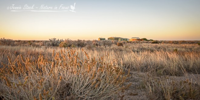
Highlights included some amazing station stays at Wooleen Station, in the Gascoyne, Hamelin Bay Station near Shark Bay, Quobba Station north of Carnarvon, Bullara Station on the way to Exmouth and Pardoo Station on the northern coast. In Broome we stayed at the awesome Broome Bird Observatory and on our way back south we detoured to Millstream-Chichester National Park in the Pilbara.


The heart of the Nullarbor

Sunset on the Nullarbor

The Nullarbor is most definitely well-named, from the Latin words Nullus arbor, meaning No trees. The seemingly endless flat plain covers an area about the size of the State of Victoria. Once a shallow sea-bed, the Nullarbor is the world’s largest karst landform. South of the Nullarbor is the Great Australian Bight, essentially a very large bay with steep cliff faces. We stopped briefly at a couple of the viewing platforms – with me cursing that the light was in the wrong place for landscape photography – and made it to the Nullarbor Motel just before sunset. Not long before reaching the motel, David and I saw a dingo on the side of the road, and then discovered that the golf hole at the motel was called the Dingo’s Den. Interrupting dinner to take some photos of the sunset, I got another glimpse of a dingo – of course, I had my very wide angle lens one so the dingo is a speck in the distance. He is on the edge of the Royal Flying Doctor Service airstrip; the RFDS is a lifesaver for residents and travelers in the Australian Outback.


Next morning saw the beginning of the last golfing day, with some fun hunting balls around the Dingo’s Den. This was followed by some very hot and dusty holes in places with odd names (Nundroo and Penong). Finally we made it to the golf course in Ceduna for the last two holes! A visit to the Visitor Centre to get the cards signed off (and to David’s relief, to hear that there were much worse scores on record) was followed by a well-deserved 19th hole in the air-conditioned comfort of a Ceduna pub.

Eyre Highway

Balladonia bushland©Jennie Stock – Nature in focus
First stop on the Eyre Highway after Fraser Range was Balladonia. The golf hole here is named “Skylab” in homage to the bits of the NASA space station that scattered its bits all over the area in 1979. The Balladonia Motel includes a museum with some interesting displays and information, and provided a decent cup of coffee to keep the support crew awake while the men wrestled with the ‘fairway’. The opening image for this post was taken more or less from the tee; if you look carefully you can see a red sign in the centre behind the trees, marking the green’s whereabouts. No signs showing where the golf balls went to!


Balladonia also marks the beginning (or end) of the 90 Mile Straight – one of the longest stretches of straight road (146.6 km) in the world – between here and Caiguna. Definitely not the most scenic drive, although the blowholes near Caiguna were interesting (just not very photogenic). Cocklebiddy was the next stop – this is the launching point for visiting the Eyre Bird Observatory, something I would have loved to do. Unfortunately that would have required a 4WD drive camper and more time than we had available, as the road into this part of the Nuytsland Nature Reserve is really rough. Instead we spent the night at Madura Pass, a much prettier campsite than I was expecting. A highlight for me here was seeing my first wild Major Mitchell’s cockatoos – didn’t get the best pictures but so happy to see them.


We spent a bit of time the next day exploring Eucla, the next stop on the golfing agenda. The hole’s name “Nullarbor Nymph” references an interesting story/hoax about a woman living with kangaroos, cooked up as a publicity stunt for the area. A short drive towards the coast allowed us to explore the ruins of the old telegraph station and the remnants of a jetty once used for bringing in supplies. Blinding white sands made this a tricky location for photography in the middle of the day – thank goodness for polarising filters.


Finally after nearly 1500 km we reached the eastern end of Western Australia at the WA/SA Border Village, a very boring but descriptive name. The sign makes you feel a long way from anywhere!

Crossing Australia with golf as a distraction

Wave rock with my son providing some sense of scale

Just over a year ago (yes, I know, I’m a bit behind), we began our trip driving across Australia from Perth to Canberra. Wave Rock, one of Western Australia’s iconic tourist attractions, was our first overnight stop. Not one of the easiest things to photograph effectively, the wave is the eroded northern face of the granite formation known as Hyden Rock. I suspect landscape photographers would have to pick the time of year (in other words, the angle of light at sunset/sunrise) very carefully to get great images. It was a lot bigger than I expected and fun to climb up and wander around the top of the rock. I enjoyed a bit of bird photography around the campsite.


Next stop was Kalgoorlie, famous for its goldfields, and the Western starting point of the Nullarbor Links, the world’s longest golf course. This golf ‘course’ kept us entertained for the next six days, with my son and husband playing the holes as we traveled – I just took photos and videos (and did quite a bit of giggling). The first two holes are part of the lovely Kalgoorlie Golf Club – from a golfing point of view, things went downhill pretty rapidly after that!


The next three holes were still on actual golf courses, at Kambalda and Norseman, but they did leave a bit to be desired in terms of grass.


The patches of the Great Western Woodlands we passed through were much more interesting. The GWW is huge, covering about 16 million hectares of Western Australia. Driving through the woodland over a few days really makes you realise how awesome it is – so wonderful to know there are still some trees left on our planet! This information from DPAW’s website is a good summary: “It is regarded as the largest remaining area of intact Mediterranean-climate woodland left on Earth and contains about 3000 species of flowering plants, about a fifth of all known flora in Australia. It includes nearly a quarter of Australia’s eucalypt species, many of which grow nowhere else in the world, and its varied habitats are home to a diverse array of mammals, reptiles, frogs and birds. Aboriginal occupation has been dated to at least 22,000 years and the region has great cultural significance, with Aboriginal people retaining strong links with and responsibility for country.”

This final image was taken just next to the caravan park in Norseman so pretty much in the middle of the Great Western Woodlands, late in the afternoon.


Sunset in the Great Western Woodlands, Norseman

Birds and buffalo

A very pretty Mourning dove in camp at Satara

Satara is a lovely camp – we all wished for more nights there. What should have been a post-lunch siesta time was spent stalking birds, like this lovely Mourning dove, in front of the rondavels (the round thatched huts typical of Kruger). I wish I managed a better shot of the Green Wood-hoopoes; they were very busy foraging for bugs in gaps in the bark of a tree. The Red-billed buffalo weaver was much more relaxed.

During our late afternoon drive heading north from camp, we came across a huge herd of Cape buffalo. I changed to my wide-angle lens to try and capture a sense of the size of the herd. It probably would have worked better if I could have got out of the car and low down, with one buffalo in the immediate foreground – but I wasn’t going to try that. Buffalo may look a bit like cattle but they aren’t one of the Big Five for nothing! Even this one trying to scratch his head looks a bit dangerous, especially when you look at those horns closely.

We stayed out as late as we could – as ordinary tourists in Kruger you have to be back in camp when the gates close at sunset. Some vultures hanging about in a tree were intriguing but too far away to see if there was something exciting on the ground attracting their attention. I am glad I managed an African sunset shot – not bad for handheld at 250mm.

Vultures settling in a tree at sunset

Mountains and mountain passes

Tradouw Pass with aloes

There are plenty of mountains and mountain passes in the Western Cape. One of the more interesting passes is the Tradouw Pass, which crosses the Langeberg between Swellendam and Barrydale. Completed in 1873, it was built by convict labour under the direction of road engineer Thomas Bain. During rebuilding in the seventies, several lay-byes were built, making it safer to stop and take photographs. Dramatic red aloes were flowering when we visited. The pass cuts through a section of the Cape Fold Mountains, and the folds and twists in the sandstone are clearly visible. These folds and twists are even more obvious when driving our usual route to Montagu through the Kogmanskloof. Great for impromptu geology lessons!

Du Toitskloof is another awesome pass – it used to be part of the major route into Cape Town from the north but these days there is an impressive tunnel through the mountain that takes most of the traffic. We drove over the top using the old pass very early one misty morning on our way to Franschhoek and stopped a couple of times, resulting in these stitched panoramas.

Looking back towards the Hex River mountains from Du Toitskloof
Looking from Du Toitskloof towards the Hex River mountains

Looking south towards Paarl and Wellington from the top of Du Toitskloof

And then we get to the Western Cape’s most iconic mountain – Table Mountain in all her glory, seen from the V&A Waterfront, a combined tourist attraction and working harbour.
Table Mountain and Devil's Peak on the left, from the waterfront.
Table Mountain and Devil’s Peak on the left, from the waterfront.